 Photinerary
Terrain, 3D and View from Here
When the sun really reaches you, a 3D look along the shot, and a first-person view through your own lens.
When the sun really clears the terrain
Published sunrise is when the sun crosses a perfectly flat horizon. In a valley, under a ridge, or beside a cliff, the sun reaches you later and leaves earlier. Photinerary works out the real horizon around a point from elevation data and tells you when the sun and moon actually appear over it.
- Times of Day shows a Terrain Here section when the terrain changes the time by five minutes or more. On the Yosemite Valley floor on 7 October, sunrise is 6:58 AM but the sun clears the walls at 8:02.
- The Shot Planner shows a caption under the sky readings with when the sun and moon clear the terrain from your pin, and fades the sun and moon lines while they're hidden behind it.
- Line of sight: with a subject set, a small profile shows the ground between you and the subject, and warns when a ridge blocks the view.
The elevation data has cells about 30 m across and doesn't include trees or buildings. A forest edge or a building next to you can still hide the sun when the terrain doesn't. Buildings are added in View from Here; see below.
The 3D map
- In a shot, tap the 3D button on the right of the map.
- The map switches to satellite imagery and tilts into Apple's 3D terrain, from just behind you, looking along the shot. Your field of view and the sun and moon lines are draped over the ground.
- Pinch, drag and rotate to look around. Tap 3D again for the flat map.
You can switch back to the plain map style while in 3D. Apple limits how far the camera can tilt, so this is a raised look along the view, not eye level. For eye level, use View from Here.
View from Here
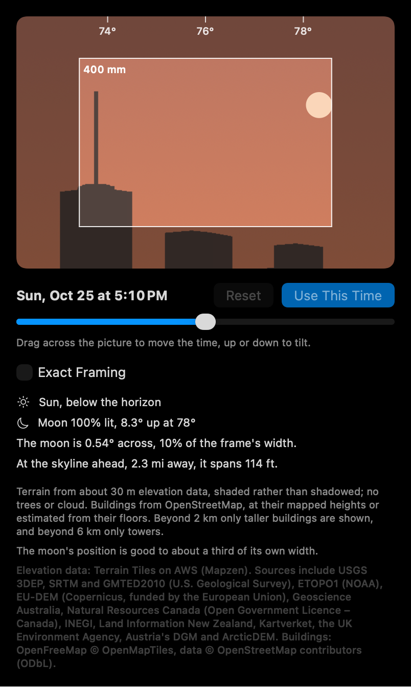
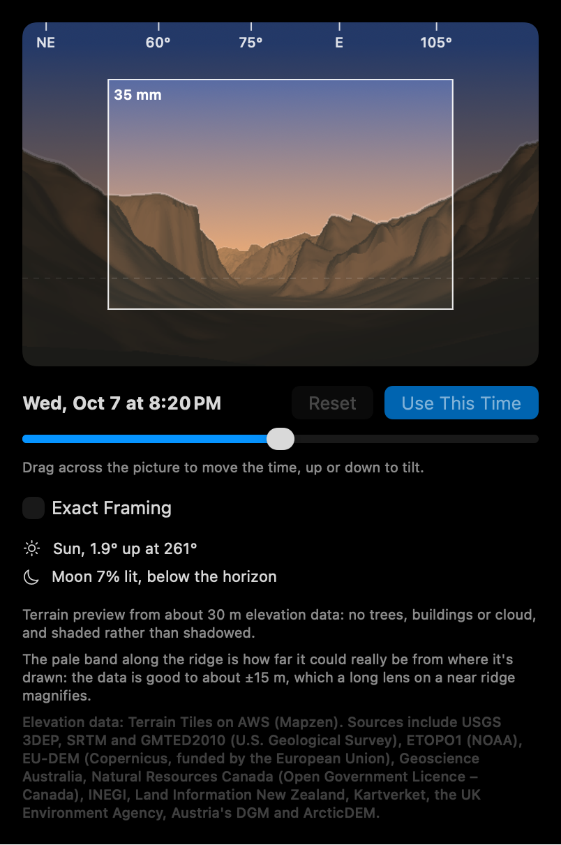
View from Here shows what your own lens will see from the photographer pin, along the shot, at the shot's time: the terrain, buildings in cities, and the sun, moon and Milky Way in their true positions and at their true size.
- In a shot, tap the binoculars button on the right of the map.
- The picture loads in a second or two (the first time in a new area downloads elevation and building data). The white rectangle is your lens's exact frame; the wider view around it is for context.
- Drag left or right across the picture to move the time and watch the sun or moon move. Drag up or down to tilt the view. Or use the slider under the picture.
- Turn on Exact Framing to see only what's inside your frame.
- When you find the moment you want, tap Use This Time to set the shot to it. Reset goes back to the shot's own time.
Why the focal length matters
The moon is always about half a degree wide. At 24 mm that's a dot; at 600 mm it fills a fifth of the frame and towers over a ridge 10 km away. View from Here draws it at its true size for your lens and for that night, so a supermoon is visibly bigger than an ordinary full moon. Under the picture you'll see how much of the frame's width the moon fills, and how wide it is at your subject's distance (about 9 m for every kilometre).
What's drawn true
- The moon is drawn where it actually appears from the ground, which near the horizon is up to a degree lower than a simple calculation gives. That's two of its own widths, exactly where it meets a ridge.
- The atmosphere lifts a low sun or moon by about half a degree and squashes it, and both are drawn that way.
- The moon's phase is shown, with its lit side turned toward the sun.
- The Milky Way is drawn along its real path across the sky, appearing as the sky gets fully dark and washing out under a bright moon.
- The terrain is shaded by the real sun direction, so ridges catch the low light at golden hour.
Buildings
In cities, buildings from OpenStreetMap are drawn at their mapped heights, or estimated from their number of floors. Nearby, every building is shown; beyond 2 km only taller ones, and beyond 6 km only towers, since lower buildings far away can't show over what's in front. That's enough to see the moon rise beside One World Trade Center from across the Hudson.
How far to trust it
- The terrain comes from elevation data with cells about 30 m across. It doesn't include trees, cloud, or anything not in OpenStreetMap.
- At long focal lengths a pale band appears along a nearby ridge. It shows how far the ridge could really be from where it's drawn: the data is good to about ±15 m in height, which a long lens on a near ridge magnifies.
- The moon's position is good to about a third of its own width. For a critical alignment, plan to be there a few minutes early.
- The picture is shaded rather than shadowed: a ridge doesn't cast a shadow on the ground behind it.